
Soil stories from our patch
Three Surbiton roads, three very different soils
Before we lift a spade, we read the ground. Here is what our soil reader found under three roads with Surbiton postcodes: our own road, a Long Ditton street of big Edwardian houses, and a hill with a church that was bombed in 1940. Same postcode area, very different gardens.
How we read your ground
Most garden problems we are called out to start below the surface: lawns that sit in water all winter, patios that sink, fences that lean, shrubs that sulk. So every Flourish garden starts with the same five checks. Our free soil reader runs the first three for any road in our area.
- The geological map. We look up the British Geological Survey (BGS) 1:50,000 mapping for the exact spot: the bedrock, and any younger deposits such as river gravel or brickearth lying on top.
- Real boreholes. BGS holds logs from wells and site investigations. When one sits close by, it tells us what the ground is actually like a few metres down, and where water sits.
- Old maps, tithe records and local history. Farms, brickfields, ponds, filled pits and bomb sites all change what you find when you dig. Victorian Ordnance Survey maps, the tithe surveys of the 1840s and local records show what was there before the houses.
- The spade. On a site visit we dig, squeeze and soak. Nothing beats a hole in the actual garden, because every plot has its own builders’ rubble and its own history.
- The right plants and the right build. We match planting to the soil using RHS guidance and our own experience, and we design drainage, bases and foundations for the ground, not for a brochure.
The three roads at a glance
| Egmont Avenue | Effingham Road | St Mark’s Hill | |
|---|---|---|---|
| BGS mapped ground | London Clay at the surface | Langley Silt (brickearth) over London Clay | London Clay at the surface, brickearth at the foot of the hill |
| Nearest borehole | 1930 laundry well, 340 m away | 1987 Thames Water borehole, 230 m away | 2024 site investigation, 130 m away |
| Drainage | Slow. Wet in winter, cracks in summer | Better near the surface, then clay | Slow, with water perched on the clay |
| Watch out for | Clay shrinking near trees | Silt that slumps when wet | Deep made ground and old rubble |
| Plants that thrive | Roses, Viburnum, Malus | Most things, bulbs especially | Tough shrubs and moisture-tolerant perennials |
Road one · Tolworth edge, KT6
Egmont Avenue: our own back garden
We start at home. Flourish House is on Egmont Avenue, and the office is at the bottom of the garden, so this is the soil we know best. It is also the soil that taught us the most.
For most of the 1800s the Earls of Egmont were the big landowners in Tolworth, and the road almost certainly takes their name. After the 7th Earl died in 1897 the farmland was sold for building. Development was slow at first, partly because the land drained so badly. Anyone who has dug a border here in February will understand why.
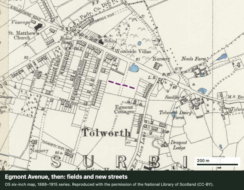
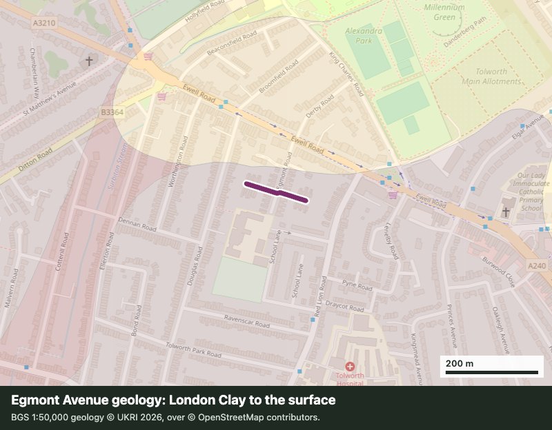
Then and now. On the Victorian six-inch map, the line of Egmont Avenue (dashed) is still a field edge, with Tolworth Dairy Farm, a nursery and Egmont Cottages close by. Tolworth’s common fields had already been enclosed under an Act of 1818. At the time of the tithe survey in the 1840s, Talworth was a detached part of Long Ditton parish, so these fields were most likely recorded in the same tithe district as Effingham Road.
What is under the lawn
The BGS map shows London Clay right up to the surface along the whole of Egmont Avenue, with no gravel or brickearth on top. That is the 50-million-year-old sea-bed clay that sits under most of Surbiton.
How thick is it? In 1930 the Royal Windsor Laundry on Lenelby Road, about 340 m away, sank a well to 192 m to reach clean water in the chalk. The log, now held by BGS, records about 3.6 m of surface material, then roughly 95 m of London Clay before the drillers broke through into sand. Below that came more clays and sands, and the chalk at 131 m. That is a lot of clay between us and the water.
The clay has been put to work locally for centuries. A short walk up Ewell Road, the ponds in Fishponds Park began as pits dug for brick earth, and a brick kiln appears there on a map of 1762.
Planting on Egmont clay
Clay is rich and holds water, so the right plants grow big and fast. The RHS lists these among its best performers on clay:
- Trees: Malus ‘Evereste’, Amelanchier ‘Robin Hill’, Crataegus persimilis ‘Prunifolia’, Sorbus aria ‘Lutescens’
- Shrubs: Viburnum tinus ‘Eve Price’, Hydrangea quercifolia ‘Snowflake’, Philadelphus ‘Belle Etoile’, Rosa
- Perennials: Geranium ‘Orion’, Anemone × hybrida, Rudbeckia fulgida var. sullivantii ‘Goldsturm’, Persicaria amplexicaulis
Plant in autumn or late winter, dig in coarse organic matter and mulch at least 5 cm deep. Break up the base of each planting hole, or it fills like a bucket. Our guide to improving clay soil goes further.
Building on Egmont clay
- Soakaways rarely work. We test before we trust one, using the BRE Digest 365 method. On this clay we usually lead water to a rain garden or a storage crate instead. More on drainage and flooded gardens.
- Patios need a deeper base. We dig out the soft weathered clay and use a geotextile under the sub-base so it does not pump up into the stone. See our patios, paths and driveways.
- Clay moves with the seasons. It swells when wet and shrinks when dry, most of all near thirsty trees. We follow NHBC Chapter 4.2 guidance on depths for footings near trees.
- Lawns need help. Hollow tine and top-dress with sharp sand each autumn, or plan land drains for a new lawn.
Wartime footnote. Tolworth took its share of bombs. A delayed-action bomb landed at 78 Ewell Road on 3 November 1940 and went off eight hours later. Rubble from bomb sites was later tipped into a flooded clay pit nicknamed “the Bluey”, now a recreation ground. Clay, again, doing the heavy lifting.
Road two · Long Ditton, KT6
Effingham Road: brickearth, flint gravel and a doodlebug
Effingham Road has a Surbiton postcode but sits in Long Ditton, in Elmbridge. It is lined with large late Victorian and Edwardian houses on deep plots, and Elmbridge’s own character study calls it somewhat unique for this part of the borough. We design and build gardens across Thames Ditton and Long Ditton.
Before the houses this was open farmland, and the parish was known for growing things. Barr and Sons, the nursery of Peter Barr, “the Daffodil King”, had grounds in Long Ditton. Around two million daffodils were reported growing there in 1898. We have not yet pinned down exactly which fields they used, but every garden here deserves a few Narcissus for old times’ sake.
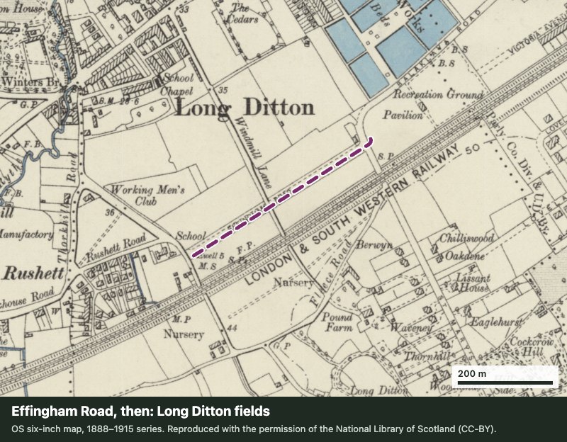
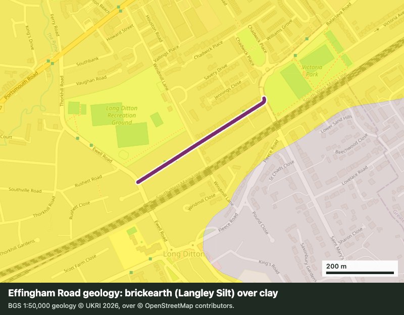
Then and now. On the Victorian six-inch map there is no Effingham Road yet (its line is dashed): just fields between Windmill Lane and the London and South Western Railway, with a recreation ground and the waterworks filter beds to the north. On the geology map, the yellow is the brickearth. Long Ditton’s tithe map, which records who owned and farmed each field in the 1840s, is held at Surrey History Centre.
What is under the lawn
This is the one with layers. The BGS map shows Langley Silt along the whole road: a fine, silty brickearth blown and washed into place at the end of the last ice age, lying on top of the London Clay.
In 1987 Thames Water drilled an observation borehole at the old Surbiton water treatment works on Portsmouth Road, about 230 m away. It found 5 m of soil, silty clayey sand and flint gravel, then 85 m of London Clay, then sands and clays, and chalk from 123.5 m. Towards the river, the BGS map turns to Thames alluvium.
So the picture under Effingham Road is likely silty brickearth, then old river sand and flint gravel, then clay. That is the classic Thames-side profile, and it is why gardens a few hundred metres apart can behave so differently.
Planting on Long Ditton brickearth
Brickearth is the gardener’s friend: fertile, easy to work and holding enough moisture without drowning roots. Almost everything grows. On the lighter patches it can dry out, so mulch well.
- Bulbs: Narcissus ‘Thalia’ and Narcissus ‘February Gold’, for Peter Barr
- Shrubs: Viburnum opulus ‘Roseum’, Cornus sanguinea ‘Anny’s Winter Orange’, Sarcococca hookeriana var. digyna
- Perennials: Astrantia major, Helenium ‘Moerheim Beauty’, Symphyotrichum novae-angliae, Iris foetidissima
The one fault: silty soil crusts on top after heavy rain. Keep it covered with mulch or plants.
Building on brickearth
- Silt slumps when wet. We dig bases in dry spells where we can, and keep excavations covered.
- It can heave in hard frost. Sub-bases go deep enough and are made of free-draining stone, never the dug silt.
- Soakaways can work here if they reach the gravel. A BRE 365 test tells us before we commit.
- Fence posts hold well in the silt, but we set them in concrete with the top sloped to shed water. See fencing and screening.
Wartime footnote. Long Ditton Village Hall, on Effingham Road, was badly damaged by a V1 flying bomb in 1944. At the time it was being used as a British Restaurant, one of the wartime canteens serving cheap hot meals, and the bomb struck shortly before lunch.
Road three · Surbiton town centre, KT6
St Mark’s Hill: a church, a bomb and three metres of rubble
St Mark’s Church stands on the hill above Surbiton station, at the heart of the new town built in the 1840s. Thomas Pooley bought the farmland here in 1838, when the railway arrived, and the bankers Coutts took the estate on in the early 1840s. The church was built in the mid-1840s and enlarged in 1855.
On the night of 2 October 1940 bombs fell on St Mark’s Hill and one hit the church roof. Burst water mains left the fire crews short of water, but they kept the spire wet and saved it. The roof and most of the chancel were lost, and gravestones were thrown across the churchyard. The parish worshipped in a tin-roofed hall for twenty years, selling bricks at £5 each to raise money, until the rebuilt church was consecrated in 1960.
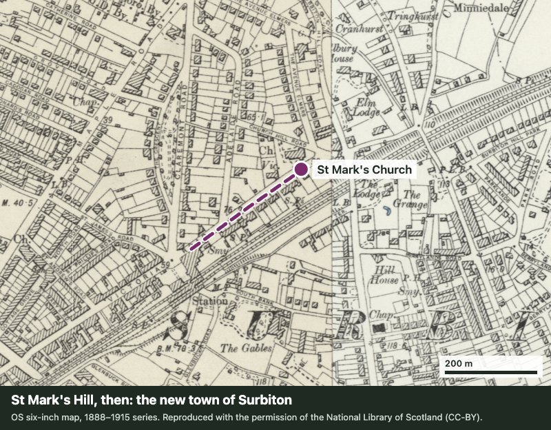
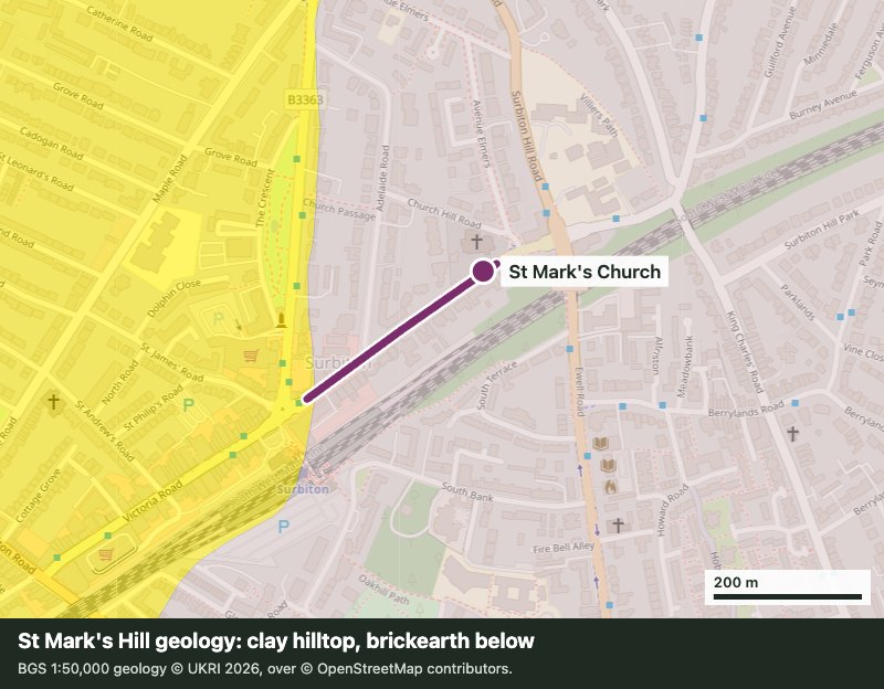
Then and now. By the time of the Victorian six-inch map the hill was fully built up, with the church at the top and villas down the slope to the station. Go back fifty years to the Kingston tithe map of 1840, drawn by Thomas Crawter, and this was still farmland changing hands as Pooley’s new town began. The original is at Surrey History Centre, with a copy at The National Archives (IR 30/34/75). On the geology map, the pink is London Clay and the yellow is the brickearth at the foot of the hill.
What is under the lawn
We expected gravel here. The ground said otherwise. The BGS map shows the hilltop as bare London Clay. The brickearth only starts at the foot of the hill, along Claremont Road, Maple Road and Victoria Road. Surbiton’s Medical Officer of Health noted the same thing in 1936: the town’s ridge runs from a spot once called Clay Hill, now Villiers Avenue. The name was a clue.
The best evidence is recent. In March 2024 engineers drilled a 25 m borehole for a development on Church Hill Road, about 130 m from the church. Under 0.4 m of topsoil they found 2 m of made ground, the lower part full of brick, tile and flint. Then came mottled orange and grey clay, and stiff grey London Clay from 5 m. Water struck at 3 m, sitting on the clay.
That top two metres is Surbiton’s history in a bucket: Victorian building spoil, garden rubbish and, quite possibly, a little of the Blitz.
Planting on St Mark’s Hill
Made ground varies garden by garden, from good loam to brick rubble, and the clay beneath stays wet in winter. Plants need to cope with both wet and dry. The RHS list for these conditions includes:
- Shrubs: Cornus alba ‘Sibirica’, Physocarpus opulifolius ‘Diabolo’, Hydrangea arborescens ‘Annabelle’
- Perennials: Astrantia major ‘Claret’, Bistorta officinalis ‘Superba’, Geranium Rozanne, Iris sibirica
- Trees and hedging: Carpinus betulus, Amelanchier lamarckii, and Taxus baccata, as the old yews in the churchyard show
Where water sits, raised beds about 20 cm high make a big difference.
Building on St Mark’s Hill
- Find natural ground first. Made ground settles unevenly. Footings for walls and garden rooms go down through it to firm clay, which here can mean more than 2 m.
- Expect perched water. Rain soaks through the rubble and stops on the clay. Any dig below a metre or so may fill. We plan drainage before we build, not after.
- Old services and old finds. We hand dig near boundaries and record anything unusual. In a town this old, the ground keeps surprising us.
- Soakaways are a long shot on the clay. Rain gardens and planted swales do the job better.
What these three roads tell us
Three roads within about 2.5 km of each other, all with KT6 postcodes. One is solid clay, one has brickearth and flint gravel over the clay, and one sits on two metres of Victorian and wartime rubble. A plant list or a patio spec written for one would fail on the other two.
That is why we read the ground first. It is quicker and cheaper to know before we dig than to find out after the patio has sunk. It is the first step in every garden design and planting plan we draw, and every garden we build in Surbiton.
Read the ground under your own garden
Our free soil reader takes about five minutes on your phone. It checks the history, slope and streams for your road, walks you through a squeeze test and a drainage test, and gives you your soil type and the plants that will love it.
Try the soil reader Ask us to look at your soilQuestions about soil in Surbiton
What type of soil is Surbiton on?
Mostly London Clay. On the higher ground, around Tolworth and Surbiton Hill, the clay comes right to the surface. Nearer the Thames it is covered by brickearth (Langley Silt) and, in places, river sand and flint gravel. Older plots, especially near the town centre, often have a metre or more of made ground on top.
Can I use a soakaway on London Clay?
Usually not on its own. Clay lets water through very slowly, so a soakaway can sit full for days. We test the ground first using the BRE Digest 365 method. Where it fails, rain gardens, planted swales or underground storage crates are the better answer.
What grows well in Surbiton clay soil?
Plenty. Roses, Viburnum, Malus, Amelanchier, hardy Geranium, Anemone × hybrida and Rudbeckia all thrive. The trick is to add coarse organic matter, mulch every year and plant in autumn or late winter rather than in high summer.
Is the soil reader accurate for my exact garden?
It gives you the area geology and history for your road, plus your own test results. Area geology is a general guide, and every garden has its own past. For a build or a full planting scheme we dig and test on site.
Sources and data credits
- Geology and borehole records: British Geological Survey, 1:50,000 mapping and Single Onshore Borehole Index, including records TQ16NE71 (Royal Windsor Laundry well, 1930), TQ16NE43 (Thames Water, Surbiton water treatment works, 1987) and TQ16NE272 (Church Hill Road, 2024). Contains British Geological Survey materials © UKRI 2026.
- Historic maps: Ordnance Survey six-inch maps, 1888–1915 series, reproduced with the permission of the National Library of Scotland (CC-BY). Modern street base © OpenStreetMap contributors.
- Tithe records: Kingston upon Thames tithe map, 1840, by Thomas Crawter (The National Archives IR 30/34/75; original at Surrey History Centre); Long Ditton tithe map, Surrey History Centre. Victoria County History of Surrey, vol. 3, Long Ditton (British History Online).
- BGS Lexicon of Named Rock Units for London Clay and Langley Silt.
- Royal Borough of Kingston upon Thames, Borough Character Study: Tolworth, and the Claremont Road conservation area appraisal.
- Elmbridge Borough Council, character assessment companion guide for Thames Ditton, Long Ditton, Hinchley Wood and Weston Green.
- Reports of the Medical Officer of Health for Surbiton, 1919 and 1936 (Wellcome Collection).
- Kingston University and Kingston History Research on the bombing of Kingston and Surbiton, 1940 to 1944.
- St Mark’s Church, Surbiton, parish history; London Gardens Trust inventory, St Mark’s churchyard and Fishponds Park.
- Elmbridge Museum, Elmbridge at War; Long Ditton Village Hall history.
- RHS, Peter Barr: the Daffodil King; RHS plant lists for clay soils and for soils that are wet in winter and dry in summer.
- BRE Digest 365, Soakaway design; NHBC Standards Chapter 4.2, Building near trees.
This page was researched with AI assistance and checked by Craig Davis. Distances are approximate. Borehole findings describe the borehole site, not every garden on the road.